Last updated on September 5, 2024
Beara is a dream of a peninsula. Really!
Page Contents (click line to jump the text)
This peninsula is located on the southwest coast of Ireland. North of it is the heavily visited Iveragh Peninsula (Kerry Way and Ring of Kerry) and south of it is the rather dreamy Sheep`s Head.
Intro
Beara lies in between – between the sister peninsulas and between counties Cork and Kerry – because the border of the two counties runs once lengthwise across the peninsula.
Beara is also between the sisters in terms of its visitors. It is much less bustling than big Iveragh, but significantly larger and also more visited than little Sheep`s Head.
Sounds indecisive? But it is a perfect compromise!
If you want to hike a gorgeous peninsula with beautiful mountains and coasts without meeting too many people, Beara might be just the right peninsula for you!
The Beara Way at a glance
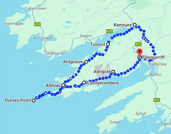
The Beara Way is one of over 40 long-distance hiking trails in Ireland. It circles most of the Beara Peninsula, with a “spur” trail to the tip of the island.
The mountains in the interior of the island are quite high. There are two roads that cross the mountains and connect the north coast with the south coast. One leads in many hairpin bends over the picturesquely beautiful Healy Pass and the other runs less steeply further in the west of the island, where the mountains are already flatter.
In the interior of the island, the mountain ridge stretches once lengthwise from the mainland, almost to the top. The Beara Way runs along the mountain slopes for long stretches. Thus you run on small paths with medium gradients above the ring road and the villages on the coast.
The route is well signposted and you are far enough above the coast to enjoy the beautiful views, but almost to yourself.
The Beara Way is about 200 kilometers long and can be walked in about 8-10 days. You can also shorten, lengthen or simply take more time, depending on your condition and time budget.
Weather and best season
The main hiking season is from April to October, with emphasis on the months of May to September.
In spring and autumn you can expect temperatures of about 12-16 degrees, in summer about 18-25 degrees.
There can always be a rain shower, as in Germany (for example).
In winter there are more often stormy winds with a lot of persistent rain. Much more than in summer.
On the coast you always have to expect wind, even in summer.
By the way, we live in Ireland, at least as a second home. In summer we run our motorcycle rental business here (www.easycruiser.tours). We also have nice guest rooms for hikers, motorcyclists, golfers, etc…So we know the weather very well from our own experience.
Tips for clothing
The well-tried onion principle also helps here: rather several thin layers of clothing than one thick one.
There can also be cool days. Good functional underwear is important. It helps to wick away sweat and keeps you warm. It requires little packing space and can also be used as pajamas.
Avoid cotton! Cotton gets damp quickly and dries poorly, thus promoting cooling. Synthetic fibers or wool-synthetic fiber blends are better.
Good hiking socks (synthetic fiber or wool-synthetic fiber) and medium-strength hiking boots are also important. You will walk partly on rough paths and the underground. can also get wet sometimes. Especially in spring and autumn I would recommend ankle-high and waterproof hiking boots.
You should always have rain gear with you. In summer at least a waterproof jacket and in the cooler season also waterproof pants.
Arrival by public transport
Dingle is relatively easy to reach by public transport. There is a bus terminal directly at Dublin Airport. There you can take the 704x bus to Cork and then the 236 bus to Glengarriff.
You can also take the bus to Dublin City and then from there take the train to Limerick and then continue by bus.
There are several routes and options, for timetables and tickets online see www.irishrail.ie and www.buseireann.ie.
Alternatively you can walk the Beara Way on from Kenmare, or start in Kenmare and finish on Glengarriff – whichever you like.
Overnight stays on the Beara Way
Beara is less visited than for example Iveragh (Kerry Way, Ring of Kerry). But there is quite a good infrastructure, which is prepared for guests. You will find B&Bs all over the island as well as hostels, campings and other accommodation.
I would highly recommend booking well in advance. On the one hand, you usually get better prices, on the other hand, it is unpleasant when you arrive in the evening at the (non-reserved) accommodation – and then it is occupied and the next one is 10km away…
We mostly use the apps from Booking.com or Airbnb to research and book accommodation. Both platforms are very well represented in Ireland and work great.
If you’re thinking about wild camping, I have written an article about it, which I will link for you at the end of this article.
The daily stages of the Beara Way
Below you will find a breakdown with 11 stages as a template. Of course you can divide the route differently in your own planning.
In this template, for example, a round trip from Castletownbere over Bear Island and a half day trip to Dunboy Castle are missing, which you can additionally include:
Day 1: From Glengarriff to Adrigole, about 16 km.
Day 2: From Adrigole to Castletownbere, about 22 km.
Day 3: From Castletownbere to Allihies, about 14 km.
Day 4: From Allihies to Dursey Island, about 15 km.
Day 5: From Dursey Island back to Allihies, about 15 km.
Day 5: From Allihies to Ardgroom, about 24 km.
Day 6: From Ardgroom to Tuosist, about 18 km.
Day 7: From Tuosist to Kenmare, about 17 km.
Day 8: From Kenmare to Glengarriff, approx. 24 km.
Information sources about the Beara Way
Here I have written down some nice sources of information for you Printed walking guides and maps:
I have found a good Irish online store where you will find what you are looking for – just click here.
Maps for download
Tough Soles: The interesting blog of Ellie and Carl offers a lot of information about more than 40 long-distance hiking trails, which both have hiked together. They’ve made some very good downloadable hiking maps of their own, which you can download here.
Apps for the smartphone
There are good navigation apps for your smartphone for when you’re on the go:
Hiiker offers maps, including to the Beara Way – click here.
From Komoot there are single map sections for the Beara Way – you can have a look if that helps you.
Conclusion
Beara is a very, very beautiful peninsula. No, that was not a spelling mistake, I mean really very, very beautiful peninsula.
Here you will find a lot of unspoiled nature – fantastic mountains and beautiful coasts. I know, I wrote that for Dingle and Iveragh (Kerry Way) too.
But in contrast to Dingle and Iveragh, it is more quiet on Beara. The roads are predominantly narrower and thus hardly suitable for bus tours.
Fortunately for hikers, because so the big tourist streams stay away here.
And so you can hike Beara in all its beauty and you are mostly alone on your path!
Does that sound good to you? Then let’s go to Beara – for hiking of course!
More interesting articles for you
HIKING THE WICKLOW WAY – ALL INFO FOR YOUR VACATION PLANNING
THE KERRY WAY – ALL INFO FOR YOUR INDIVIDUAL HIKING TOUR
HIKING AND WILD CAMPING IN IRELAND – IMPORTANT TIPS!
THE ULTIMATE PACKING LIST FOR MULTI-DAY HIKES IN IRELAND
Photo credits cover photo: Beara mountains, photo by: Ulrich Knüppel-Gertberg (www.easycruiser.tours, www.irland-insider.de, www.ireland-insider.com)