In the southwest of Ireland, several peninsulas reach far into the Atlantic. One can argue about which of them is the most beautiful.
Page Contents (click line to jump the text)
Intro
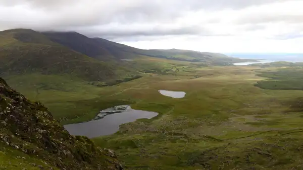
A hot contender for this throne is definitely the Dingle Peninsula. Everything about it is just right – the whole package, so to speak. In the interior of the peninsula mountains rise – there runs the Conor Pass. The road winds up in many curves and from above you can see the ocean in both directions.
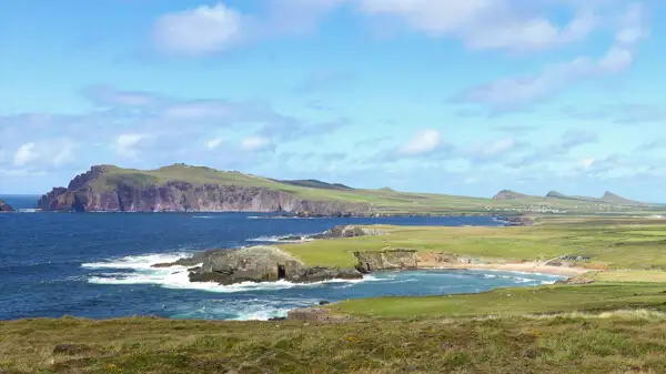
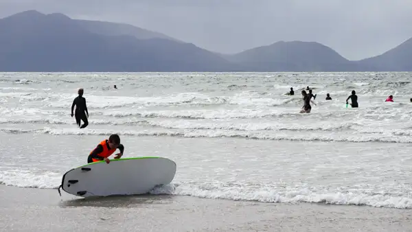
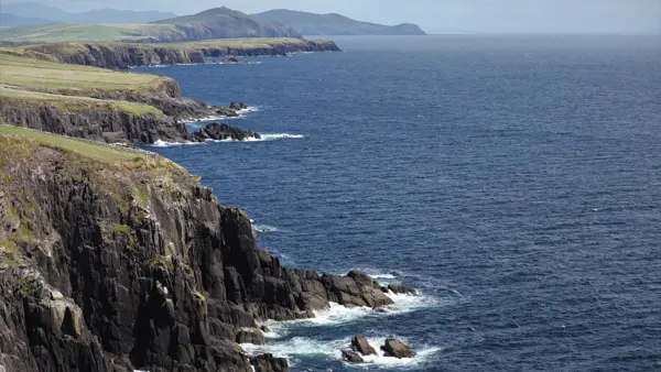
Nevertheless, the mountain massif of the Peninsula leaves enough room for wide rolling hills with many flat sections down to the sea. The coast has breathtaking cliffs, for example at Slea Head. But there are also beautiful white sandy beaches. The mixture of landscapes gives an open and friendly impression.
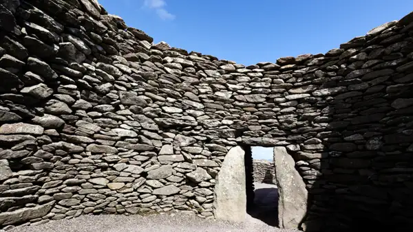
The small harbor town of Dingle is very pretty and on the south coast you will find a Celtic museum and some historic buildings, like the Beehive Huts, round huts built of stones by medieval monks.
On this gem of a peninsula runs a very popular long-distance hiking trail – the Dingle Way.
The Dingle Way at a glance
The Dingle Way stretches 179 kilometers across the peninsula. Basically you walk once around the island.
You will also walk on the mountainside, but often in the hilly or flat countryside and partly directly at the sea.
The 2900 vertical meters of the Dingle Way are well distributed over the route. Thus, Dingle also shows its friendly side when it comes to hiking.
This makes the Dingle Way much less strenuous than the Kerry Way and therefore also suitable for less experienced hikers or hikers with medium condition.
So many advantages of course attract tourists and so Dingle is one of the more visited peninsulas in the summer months.
Weather and best season
The main hiking season is from April to October, with emphasis on the months of May to September.
In spring and autumn you can expect temperatures of about 12-16 degrees, in summer about 18-25 degrees.
There can always be a rain shower, as in Germany (for example).
In winter there are more often stormy winds with a lot of persistent rain. Much more than in summer.
On the coast you always have to expect wind, even in summer.
By the way, we live in Ireland, at least as a second home (coming from Germany). So we know the weather very well from our own experience.
Tips for clothing
The well-tried onion principle also helps here: it is better to wear several thin layers of clothing than one thick one.
There may also be cool days. Good functional underwear is important. It helps to wick away body sweat and keeps you warm. It requires little packing space and can also be used as pajamas.
Avoid cotton! Cotton gets damp quickly and dries poorly, thus promoting cooling. Synthetic fibers or wool-synthetic fiber blends are better.
Good hiking socks (synthetic fiber or wool-synthetic fiber) and medium-strength hiking boots are also important. You will walk partly on rough paths and the underground. can also get wet sometimes. Especially in spring and autumn I would recommend ankle-high and waterproof hiking boots.
You should always have rain gear with you. At least a waterproof jacket in the summer and waterproof pants in the cooler seasons.
Arrival by public transport
Dingle is relatively easy to reach by public transport. There is a bus terminal at Dublin Airport. There you can take the bus to Limerick, then the bus to Tralee and if you want to go on to Dingle.
You can also take the bus to Dublin City and then from there take the train to Limerick and then continue by bus.
There are several routes and options, for schedules and tickets online see www.irishrail.ie and www.buseireann.ie.
Overnight stays on the Dingle Way
There are plenty of places to stay along the Dingle Way. I can only recommend booking them sufficiently far in advance.
Since Dingle is a popular peninsula, I wouldn’t want to stand in front of closed doors on the off chance to have to walk a longer distance to the next B&B in the evening.
We use Booking.com or Airbnb booking apps ourselves. Both platforms are very common in Ireland and work well.
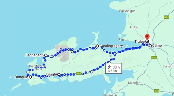
The daily stages of the Dingle Way
You can adjust your route and stages individually, depending on your fitness and time budget. If you don’t like Tralee as a starting and finishing point, you can also start and/ or end in Dingle, just circumnavigate the peninsula and save about 2 days of time.
The Dingle Way is about 179 kilometers long and can be done in 8-10 days.
Here I show you an 8-day route as an example:
Day 1: From Tralee to Camp, about 18 km.
Day 2: From Camp to Annascaul, about 17 km.
Day 3: From Annascaul to Dingle, approx. 22 km.
Day 4: From Dingle to Dunquin, about 20 km.
Day 5: From Dunquin to Feohannagh, about 22 km.
Day 6: From Feohannagh to Clohane, about 21 km.
Day 7: From Clohane to Castlegregory, about 29 km.
Day 8: From Castlegregory to Tralee, about 27 km.
Information sources about the Dingle Way
Here I have some interesting sources of information for you – Printed hiking guides and maps:
Outdoor Verlag, Diana Steinhagen, Ireland:Dingle.
Map No. 70, 1:50000 from Ordnance Survey
Download maps
Tough Soles: Ellie and Carl’s interesting blog has lots of information on over 40 long-distance trails that they have both hiked together. They have made some very good downloadable walking maps themselves, which you can download here.
There is a website from Trailhead Ireland especially for the Dingle Way, where you can find a lot of interesting information and also maps.
Apps for the Smartphone
There are good navigation apps for the smartphone for on the road:
Hiiker offers maps to the Dingle Way – click here.
Komoot also offers maps for the Dingle Way – click here.
Conclusion
The Dingle Way is a very pleasant and popular long distance hiking trail. You can walk around a beautiful peninsula with mountains on one side and beautiful cliffs and beaches on the other.
At the same time the path is well signposted, not too difficult or strenuous to walk and there is a good infrastructure for shopping and accommodation.
If you book in time, nothing will stand in the way of your wonderful hike – so let’s go! Let’s go to Dingle!
More interesting articles for you
THE SHEEP`S HEAD WAY – HIKING ON THE SOUTHWEST COAST OF IRELAND
HIKING THE WICKLOW WAY – ALL INFO FOR YOUR VACATION PLANNING
HIKING AND WILD CAMPING IN IRELAND – IMPORTANT TIPS!
THE ULTIMATE PACKING LIST FOR MULTI-DAY HIKING IN IRELAND
Photo credits cover photo: Seagulls at Slea Head, photo by Ulrich Knüppel-Gertberg (www.irland-insider.de, www.ireland-insider.com)