This is the third part of this series of articles, where we will take a closer look at the stunning mountain areas of the northern part of the Irish Isle.
In the first part, we got an overview of Ireland’s regions and looked at beautiful mountain routes in the southeast. The second part was about the southwest.
Page Contents (click line to jump the text)
Overview
Where are the most beautiful mountain routes and mountain passes for motorcyclists in Ireland:
1) Wicklow Mountains National Park, e.g. Sally Gap or Wicklow Gap.
2) The Blackstairs Mountains at Mount Leinster, e.g. Nine Stones Viewpoint.
3) The Beara Peninsula with the Healy Pass.
4) Killarney National Park, e.g. Molls Gap, Ballagbeama Gap, Ballaghisheen Pass or Gap of Dunloe.
5) The Dingle Peninsula with Connor Pass.
6) The Connemara Highlands with several beautiful mountain routes.
7) The Highlands of Mayo with several beautiful mountain routes.
8) The Benbulben with the Gleniff Horseshoe Drive.
9) The Glenveagh National Park in Donegal with several beautiful mountain routes.
10) The Mourne Mountains with the pass road over the Spelga Dam.

Beautiful mountain routes and passes in the north of Ireland:
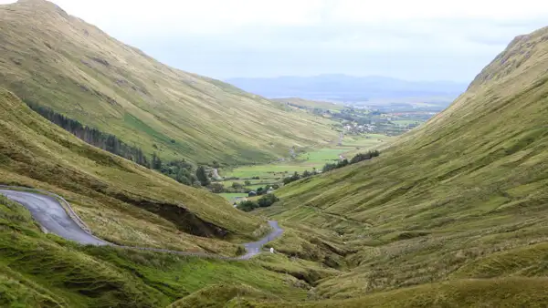
The Connemara Highlands (6)
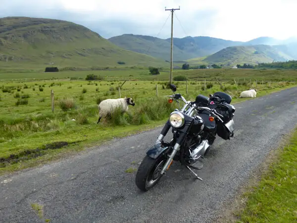
Northwest of Galway lies the rugged highlands of Connemara. In those days, farmers had a hard time making a living on the rocky ground. Only particularly hardy animals such as sheep, the tough Connemara ponies and donkeys could thrive here, and farming was mostly out of the question.
Travellers, however, love Connemara’s wild landscapes and in summer there are not a few coaches between Galway, Clifden and the famous Kylemore Abbey. Outside the main routes, however, the motorcyclist can still ride in a relaxed manner, even in summer.
Some of the most beautiful routes through Connemara’s mountains are:
a) From Pines Island Viewpoint via Lough Inagh to Kylemore Abbey.
b) From Clifden via the Sky Road Loop to the N59.
c) From Kylemore Abbey via Tully Cross, Lough Muck and Lough Fee to Killary Fjord.
To a) From Pines Island Viewpoint via Lough Inagh to Kylemore Abbey
The small coniferous island is probably one of the most photographed subjects in Connemara. But it is also picturesque with an incredible view of the mountain ranges behind.
From there, head east on the N59 (towards Galway) and turn left onto the R344 (signposted Letterfrack).
Take your time over the next few kilometres, the drive along Lough Inagh is beautiful.
At the end of the R344 you come to the N59 (yes, it is called that here), where you can turn left to Kylemore Abbey. This beautiful abbey built into the mountain is one of Connemara’s most visited highlights, so you won’t be alone there, but the visit is still very nice.
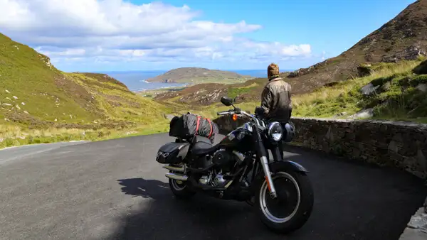
To b) From Clifden via the Sky Road Loop to the N59
Clifden is the main town of Connemara. The small town is also a good overnight stop.
In Clifden, the Church Hill Road branches off from the N59. This quickly leads to the Sky Road. Follow the Sky Road to the sea. On some steep driveways you look straight up into the sky, hence the name Sky Road. The road is largely single-lane and narrow. In summer, you should drive it early or late to avoid too much oncoming traffic. But it’s worth it: the many tight bends are really fun and the views of the coast are at their best. The road leads up to the headland and in a big curve back to the N59.
To c) From Kylemore Abbey via Tully Cross, Lough Muck and Lough Fee to Killary Fjord
This route is less frequented and almost an insider tip: From Kylemore Abbey you drive a short distance on the N59 in the direction of Clifden. Turn right into the small road to Tully Cross. In Tully Cross turn right onto the Connemara Loop, along the coast. Follow the road until you reach the two lakes Lough Muck and Lough Fee – the lakes are beautifully embedded in the mountains. A small climb soon brings you back to the N59, where you can turn left towards Killary Fjord or Killary Harbour. This is the only fjord in Ireland and cuts about 45km deep into the country. The winding drive there is a pleasure in itself.
The Highlands of Mayo (7)
Mayo is less well known than Connemara, but at least as beautiful. The mountains are not quite as rocky as in Connemara, but there is a lot of high moorland. The rounded green hilltops with their peaty scars look like a smaller version of the Scottish Highlands.
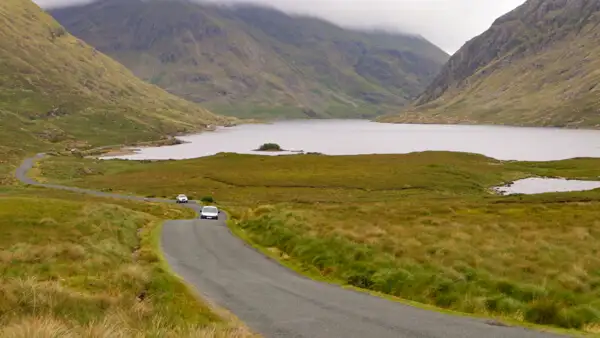
At Clog on Killary Fjord you are already in Mayo. Follow the fjord for a short distance and then turn left towards Delphi.
The small road (R335) leads over a small bridge. You can park there and after a few metres walk admire the Aasleagh Falls. Then follow the northern shore of the fjord until the road turns right into the mountains.
After the village of Delphi you come to a large lake, Doo Lough. There the paths diverge. You can either
a) follow the R335 via Louisburg and Craogh Patrick to Westport, or
b) turn right onto the small L1824 to Drummin and then drive via Liscarney to Westport.
To a) Via Louisburg and Croagh Patrick to Westport
You drive on the R335 along the shore of Doo Lough. The road winds uphill and you come to the car park at the Dooloug Famine Memorial. The great famine took place in the mid-19th century. This traumatic time is commemorated in many places in the country today. The place offers wonderful views of the lake and the surrounding mountains.
At Louisburgh you reach the coast again. A little further on, you will see Croagh Patrick, the holy mountain of the Irish, on your right. The 764m high mountain looks like a sugar loaf and is an important place of pilgrimage.
The view of the sea is also picturesque: numerous islands lie in the bay off Westport.
To b) Via Drummin and Liscarney to Westport
This small road (L1824) is a nice alternative and very little used. You will have sheep on the road, the Border Collies will race you – and win and the farmers will greet you friendly – in this valley Ireland is still Ireland.
The mountains rise magnificently on both sides as you drive up the small pass road. The small pass has no name, but is nevertheless beautiful.
There are many bends to Drummin and at Liscarney you join the N59 to Westport.
The Ben Bulben with the Gleniff Horseshoe Drive (8)
North of Sligo lies a mountain range with a very characteristic and steep flank – this is the Ben Bulben or Ben Bulbin mountain range.
From Sligo, take the N16 north. After a short time you will see the mountain massif in front of you. The road winds down the mountain to Glencar Lough. Pass the village of Glencar and drive along the north shore of the lake to Glencar Waterfall. The small but pretty waterfall is only a few metres from the car park and well worth the short walk.
Follow the small road west and then turn right onto the N15 north. In the small coastal town of Cliffony, turn left to Mullaghmore and right to Gleniff Horseshoe Drive. You have to look carefully to find the little signs, but it’s worth it.
On small roads you drive up the mountain to the back of the Ben Bulben massif, where you reach the “Horseshoe”, a rugged semicircular wall rising above the valley. The small farm there has long since fallen into disrepair.
Granted, you’re not very high up there, but that and the atmosphere there on the mountain is impressive nonetheless and the drive is a beautiful experience that I didn’t want to withhold.
You continue along the road and come back to the N15 on other small paths.
Glenveagh National Park in Donegal (9)
Donegal is the most north-westerly province of the Republic of Ireland and borders directly on Northern Ireland. The Republic of Ireland is a fully independent country and an EU member. Northern Ireland belongs to the United Kingdom, i.e. England, and is no longer in the EU since Brexit. This is therefore an external EU border. However, you hardly notice the course of the border, because it is completely open.
Glenveagh National Park covers a large part of the mountainous interior of Donegal.
For motorcyclists, virtually everywhere here is beautiful – you can’t go wrong.
Some examples:
a) From Dungloe past Mount Errigal to Glenveagh National Park Visitor Centre.
b) From Glenveagh National Park Visitor Centre via Lough Barra to Dungloe
c) “Surf and Turf” – Mountains and Coast in Northern Glenveagh National Park
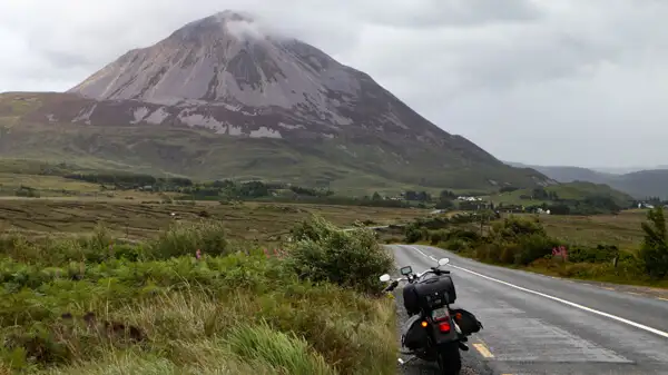
To a) From Dungloe past Mount Errigal to Glenveagh National Park Visitor Centre
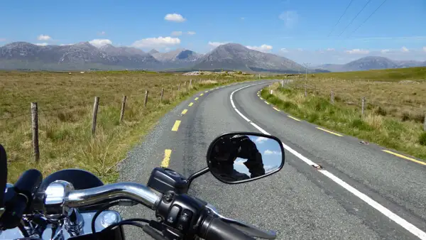
Starting in Dungloe, take the N56 north to Gweeedore. The road is easy and pleasant to drive and winds through the foothills of the Derryveagh Mountains in large arcs.
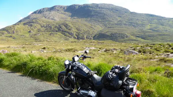
A few kilometres after Gweedore, turn right onto the R251. From a distance you can see a large sugar loaf in front of you. This is Mount Errigal. It is “only” 751m high, but looks very impressive.
You pass Mount Errigal and continue along the R251. On your right, the mountain massif of Glenveagh National Park rises. A few kilometres further you can turn right to the National Park Visitor Centre.
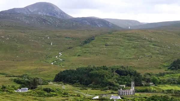
Behind the Visitor Centre begins Lough Beagh and on its banks lies the picturesque Glenveagh Castle. To visit the castle, you must park your motorbike at the front entrance and either walk a good distance to the castle or take one of the shuttle buses.
To b) From Glenveagh National Park Visitor Centre via Lough Barra to Dungloe
This could be the second part of a Gleanveagh round trip: From the National Park Visitor Centre, take the R251 south-east and follow the road to Carrickascanlon.
Turn right onto the R254 and follow the mountains through Glendowan to Doochary. Turn right onto the R252 and then right again onto the N56 to Dungloe.
To c) “Surf and Turf” – Mountains and Coast in Northern Glenveagh National Park
This is a mixed mountain-sea tour: From Glenveagh National Park Visitor Centre, drive a short distance south-east on the R251, then turn left onto the L1332 to Drimnaraw. After a few kilometres you will see the Owencarrow Viaduct on your right. Shortly after, turn right onto the N56 and then left at Currindale onto the small road past Lough Salt and into Glen Village.
Turn left onto the small road towards Creeslough. At Lackagh River Bridge turn left onto the R245 and then right onto the L5222 which will take you to Doe Castle. The pretty little castle is beautifully situated on the bay and is nice to visit and walk around.
Continue along the R245 and then turn right onto the N56, which takes you in a large arc along the coast.
At Dunfanaghy you can stop and take a closer look at the beautiful beach. Continue via Fanmore to Falcarragh. There you turn left onto the R256. The road leads beautifully through the mountains and over an old small stone bridge, the Bridge of Tears. A few kilometres further on you will reach the Glenveagh NP Visitor Centre.
The Mourne Moutains in Northern Ireland (10)
Anyone travelling through Northern Ireland should make a detour through the Mourne Mountains on the north-east coast. This group of mountains is not very large, but beautiful, both to drive around and to cross: From Hilltown, head east on the B27. At the top of the mountain you come to a dam, the Spelga Dam. You can drive halfway around it and take the entrance to the dam at its southern end and arrive at Deer Meadows Car Park, which is a great place to take a break in the beautiful mountain scenery. If you continue downhill on the B27, you can ride to the harbour town of Kilkeel on the coast – you should brake there at the latest, after that there is only the sea….
Most motorcyclists come to Ireland to ride the Wild Atlantic Way, and for very good reason. The coasts are breathtakingly beautiful in many places and even two weeks is hardly enough to admire the WAW in its entire 2500km length.
Conclusion
For motorcyclists, however, there are also many beautiful winding mountain roads and passes to discover away from the wild Atlantic coast. Of course, Ireland’s low mountain ranges cannot be compared to the much higher Alps – but they are not as crowded.
Visually, one is often reminded of the Scottish Highlands. The mountains are covered with heather and ferns, peaty bogs and barren rocky outcrops can often be seen, and sometimes you even pass through a forest. The mountain flanks are speckled with white, and there are countless cows, shepherd dogs and deer standing around on the small roads – they all have the right of way and they know it.
On these small roads off the beaten track, Ireland is still Ireland: you hardly ever meet anyone and if you do, you let them pass you in a friendly manner and always have time for a chat along the way.
This is the special charm of Ireland that delights the motorbike traveller: Ireland is magical!
You can feel it not only on the enchanting sandy beaches and small fishing harbours, in cosy pubs and standing by mighty cliffs.
You can also feel it in the steady rhythm of the endless hills, in the damp haze of the mountain mist and in the quiet solitude of the high moors. In harmony with nature and with yourself, you curve along the small roads and know that you will be back.
More interesting articles for you
THE MOST BEAUTIFUL MOUNTAIN ROADS AND PASSES FOR MOTORCYCLISTS IN IRELAND – PART 2: THE SOUTHWEST
THE BEST MOUNTAIN ROADS AND PASSES FOR MOTORCYCLISTS IN IRELAND – PART 1: OVERVIEW & THE SOUTH EAST
FROM NORTHERN IRELAND TO SCOTLAND BY MOTORBIKE – HIGHLANDS AND HIGHLIGHTS
THE 13 MOST BEAUTIFUL MOTORBIKE TOURS ON THE IRISH ISLAND
Photo credits cover photo: Pines Isle Viewpoint in Connemara, photo by Ulrich Knüppel-Gertberg (www.irland-insider.de, www.ireland-insider.com)
Picture credits map: Google Maps with handwritten additions