Ireland is a hiker’s paradise. On more than 40 long-distance hiking trails you can take in the unique and varied landscapes of the Emerald Isle step by step.
Page Contents (click line to jump the text)
Intro
The Wicklow Mountains start just south of Dublin and that’s where your path will lead you if you want to walk Ireland’s first and oldest long-distance hiking trail – the Wicklow Way.
In this article I have collected a lot of useful information about the Wicklow Way for you. Much of it I have found out myself, because I live there. At least for a few months a year. I have not walked the full length of the Wicklow Way, but I have walked many parts of it. And I know the Wicklow Mountains as a whole very well.
My family and I have our second home in the southeast of Ireland, not far from the Wicklow Mountains, where I have done a lot of hiking myself.
The Wicklow Way at a glance
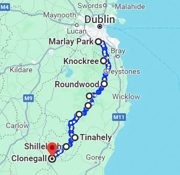
The Wicklow Way starts directly at the southern edge of Dublin and stretches for almost 130km south to the small town of Clonegal.
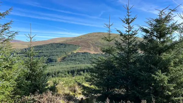
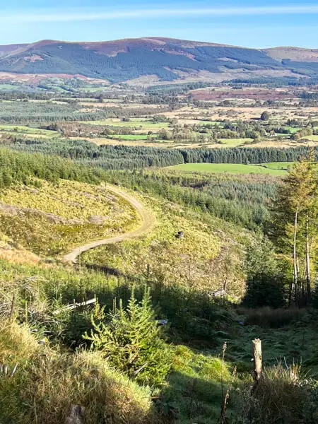
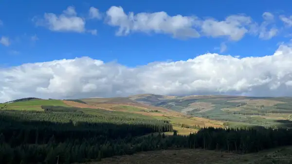
The trail follows the mountain range of the Wicklow Mountains. The Wicklow Mountains are a low mountain range, where most of the mountains are around 500-700 meters high. But it also goes higher: the highest mountain of the Wicklow Mountains and the province of Leinster is the Lugnaquilla with 925 meters height.
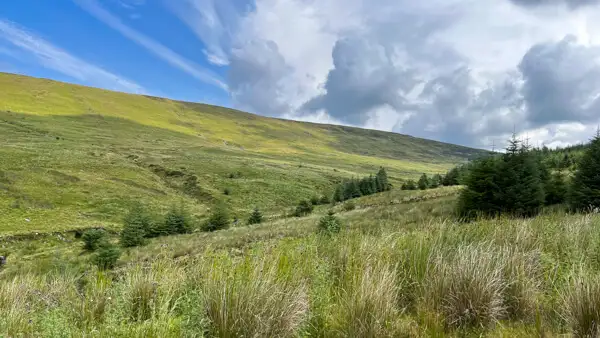
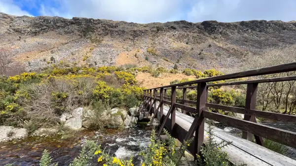
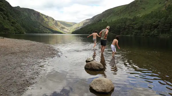
The heart of the Wicklow Mountains is the Wicklow Mountains National Park. The scenery there is particularly beautiful: secluded forest trails, babbling brooks and streams with small waterfalls, rugged cliffs and barren hilltops with high moorland that glows in summer with the fresh green of bracken and the purple of heather.
Amidst this scenic beauty also lies one of Ireland’s most important sights: the early medieval monastic site of Glendalough. Even if monasteries don’t interest you, you should make an exception here: Glen-da-Lough is a Gaelic name that means Valley of the Two Lakes. The valley is picturesquely beautiful and the monastery complex (see the round tower on the cover picture) is really idyllic. The Wicklow Way takes you through the valley and then back out over the mountain.
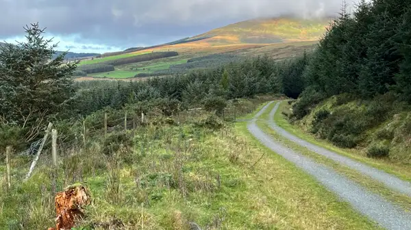
You’ll be walking long stretches on gravel forest roads, some on small paths and tracks, and some on small roads. However, traffic is still very manageable in rural Ireland and most of these little roads are really rural, so no problem.
Most hikers cover the approx. 130km total distance in stages of 6-8 days. This results in daily stages of about 15-25km or about 20km on average for most of them. However, there is a total of about 3600-3900 meters of altitude to overcome with a backpack, depending on the variant. A good condition and experience in hiking with luggage is therefore highly recommended.
Weather and best time to travel Wicklow Way
Ireland is an island in northern Europe. The climate is roughly comparable to the German coasts: Summers are warm with 20-25 degrees, but not hot. Temperatures of 30 degrees are hardly ever reached. Winters are mild and frost is rather rare. But occasionally the mountain tops of the Wicklow Mountains are powdered white.
In late autumn, winter and spring there can be stormy winds with a lot of rain. In summer there is much less rain, statistically and according to experience. But of course there can be a cool week and single rain showers even in summer and hikers should be prepared for that.
The best season for the Wicklow Way is from April to October, the core time for walkers is certainly between May and September.
Midges, small biting flies, which are very common in the Scottish Highlands and can be a real nuisance to hikers, are almost non-existent in Ireland. Mosquitoes are also not a big issue. Both can occur in valleys near standing water, but not on the mountains of the Wicklow – they don’t like the wind. If you’re sensitive to them, you should pack mosquito repellent. What else? We’ll get to that now:
Clothing and equipment for the Wicklow Way
Your daily stages will be long and there are often no opportunities for shopping on the way. So you should always carry enough water and provisions for the day – and that includes more than just a water bottle.
Rainwear is a must! You may not need it, but if you’re on the mountain in the wind and the rain is coming, you better have it with you. At least a waterproof jacket to put over, in fall and spring also waterproof pants. Ponchos I can not recommend, where in the wind and then protect little.
By the way, the onion principle applies: several light layers of clothing are better than a thick jacket. With short and long thermal underwear, hiking pants, fleece shirt and soft shell jacket you are already well dressed. A rain jacket and pants to pull over and a headgear against sun, wind and rain complete the equipment. In Ireland you see many women walking in leggings – also a good option, and for the cooler seasons there are thicker fabrics.
Avoid cotton!!! Cotton gets damp quickly – sweating is enough – and dries poorly. This makes you cool down quickly. Better are synthetic fibers or synthetic fiber-wool blends. Who makes fitness, has as well as mostly sports shirts or leggings made of synthetic fiber, they are well suited.
The backpack must be large enough, have a good carrying system and fit you ergonomically well. I wear at home on shorter tours, if you have bought him only new!
Since many routes run on gravel or stony paths, you should bring medium-firm – to firm hiking boots or trekking boots. They should be waterproof and I personally prefer ankle boots to flatter shoes. Also make sure you have well-fitting hiking socks – even synthetic fiber or synthetic fiber-wool blend.
If your smartphone won’t last all day, bring a power bank. You’ll also need a travel adapter for UK plugs.
You won’t always have reception on the road, so don’t just rely on your smartphone for navigation. A trail map or printed (and laminated) maps from the internet will help with radio silence. A small compass is also helpful. The Wicklow Way is well marked (posts with yellow “little men”), but better safe than sorry. Further down in the text you will find super maps for free download.
ID and money: In Ireland the Euro is valid. There are ATMs at all banks, but they are rare in rural areas. There you can get cash-back in stores and gas stations while shopping. Common credit and debit cards usually work in Ireland, but bring enough cash with you, because not everyone accepts cards.
By the way, you need your passport to enter the country, because Ireland is a member of the EU, but not of the Schengen Agreement.
If you hurt your foot and need help (for example), a smartphone, a whistle and a small first aid kit are helpful accessories to have, too.
Arrival and departure by public transport
There are flights to Ireland from many German airports. We mostly use Ryanair and have mostly flown well with them. If you want to travel in the summer, you should book several months in advance – that comes SIGNIFICANTLY cheaper. We usually fly well under 100€ each way.
Directly at the airport you will find a large bus or coach terminal with connections in all directions of Ireland. The Expressway lines of Bus Éireann connect all major towns in Ireland (www.buseireann.ie). There are also numerous regional and local bus operators. You can buy tickets online (cheaper) or from the driver.
You can also go to Dublin City and take the train from Connolly Station. You can find the connections online (www.irishrail.ie). You can also buy tickets online.
The entrance to the Wicklow Way is in Marlay Park, a nice park in the south of Dublin. The Dublin Bus no. 16 will take you there from the city. You can also just take a cab.
The southern end of the tour is in Clonegal. The small town is less well connected: There is a Bus Éireann Expressway bus from Busaras, the bus station near Connolly Station in Dublin City to Kildavin, a small town 3km from Clonegal.
Alternatively, you can drive to Bunclody, a slightly larger village with shopping facilities about 5km from Clonegal.
By the way, the route is traditionally described starting from Dublin and going south, but of course you can also start in the south and hike back to Dublin.
The southern two stages, between Clonegal and Tinahely have little ascent, but a higher proportion of road. The most scenic sections are between Tinahely and Dublin.
Many walkers shorten the Wicklow Way and start or end the tour in Tinahely, from there there is a sporadic bus to Arklow and from there it goes by train or bus further night Dublin. From Gorey, Bus Éireann (www.buseireann.ie) and Wexford Bus (www.wexfordbus.com) go to Dublin City and the airport and there is also a train to Dublin Connolly Station (www.irishrail.ie).
By the way, it is worth spending the last night in Dublin. You can explore the old center around Temple Bar on foot, enjoy some live music in the pub and then go to the airport the next day.
Luggage transport and short transfers between stations
If you don’t want to carry your heavy backpack all day, you can also hike with lighter day luggage and have your overnight luggage transported from station to station. Wicklow Way Baggage, for example, offers such a shuttle service (www.wicklowwaybaggage.com). You should book this service in advance.
Many overnight stations are equipped for hikers and will pick you up or take your luggage to the next station.
Cabs are somewhat scarce in the country. Where there are local providers, I will mention them in the stage description. You should definitely book in advance. Often your respective host (hotel or B&B) can help you, they will usually know a few local cab drivers or offer the short ride to the grocery store themselves.
Uber does not exist at all in the countryside, even if the Uber app makes you believe that… In Dublin, the Uber service is provided by cabs.
Places to stay along the Wicklow Way
The stops along the Wicklow Way are mostly small and rural villages. There are mainly B&Bs, but also small hotels, guesthouses and also a hostel and three open shelters, where you can camp.
Further down in the text I will describe the individual stages in more detail and also go into some specific accommodation options.
In general, you can find accommodation in Ireland very well via www.booking.com or www.airbnb.com.
You should always book your overnight stays on the Wicklow Way – many have only a few rooms and they tend to be full in summer.
Camping and Wild Camping on the Wicklow Way
You have to think about whether you really want to carry along tent equipment on the Wicklow Way, because you have to overcome a total of about 3900 meters of altitude. But if you are fit enough, there is nothing against it.
There are some campsites, which I will list at the individual stages.
Furthermore there are three huts, or better open roofs, where you can pitch your tent: The Mucklagh Hut, the Brusher`s Gap Hut and the Mullacor Hut. You can find them in the maps I recommend for free download (see below).
Wild camping is not officially allowed in Ireland, but is usually tolerated in the Wicklow Mountains if you follow the Leave-no-trace rules. The main rules are to stay on the trails, be considerate of others, don’t spook animals, don’t make an open fire (camping stoves work), and don’t leave trash behind. Good recommendations for all hikes!
In the valley of Glendalough, however, wild camping is strictly forbidden and the local rangers monitor that too!
Eating and drinking on the way
At the overnight stops on the stages there is usually a pub, a takeaway snack bar and a store to stock up on essentials or have a hearty meal in the evening.
Restaurants, by the way, are hardly recognizable – you’ll find them in the pub. Most pubs offer very good, hearty and not too expensive hot food.
For the day you should take everything with you that you need on the way, because you might be “far away from civilization”.
You can easily fill up your water bottles at the tap of your accommodation, domestic water has drinking water quality in Ireland.
Mountain streams can also be clear and safe to drink, but often the water flows through high moorland before it ripples down the slope, giving it a brownish color. This can still be drinkable, but I would use a water filter because the color is unsightly. Better to carry enough water with you.
There are concentrated hiking foods available at specialty stores, like granola bars or something similar. It’s always good to have some with you in case there’s nothing to buy.
The Wicklow Way in detail
Now we come to the stages of your way. These are quite flexible, depending on your fitness you can walk more shorter stages, or fewer but longer distances. Below you will find a very typical breakdown for the Wicklow Way.
Important: I’ll give you a few accommodation options along the way, but you can find many more on airbnb, booking.com or Trivago.
Stage 1 : From Dublin Marlay Park to Knockree (20km)
Dublin is a city of millions. Just over a million people live in or on the outskirts of the capital. Another million or so people live in the smaller towns that border or almost border Dublin.
It is all the more astonishing how quickly the border between city and country disappears – after a few kilometres you are in the Dublin Mountains and already in the middle of the forest – in the Tcknock Forest to be exact… Fairy Castle is the most famous peak there. At 536 metres, it gives you a good foretaste of the Wicklow Mountains. Geologically, the Dublin Mountains belong to the Wicklows, but they are not in County Wicklow, but in County Dublin.
The path leads alternately through forest and open country and winds its way upwards. Beyond Glencullen you reach the county border with Wicklow and a little later you reach Knockree.
Where to stay: Knockree is home to the Knockree Hostel. About 4 kilometres further on is the lively town of Enniskerry with several places to stay, such as the Enniskerry Inn.
There you will also find the beautiful Powerscourt House and Estate, a magnificent historic mansion with beautiful, huge grounds. If you have enough time, a double night stay in Enniskerry can make sense.
Stage 2: From Knockree to Roundwood (19km)
A mixture of forest tracks and small roads await you. You will also pass Lough Tay and the memorial stone of JB Malone, founder of the Wicklow Way.
Where to stay: The Coach House, Riverbank, Ashlawn.
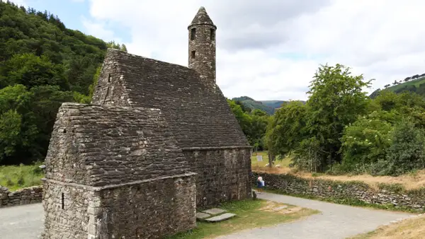
Stage 3: From Roundwood to Glendalough (10km)
Today’s stage is short, but gives you plenty of time to see the beautiful early medieval monastic site of Glendalough. Dining and accommodation options are more likely to be found in Laragh, a little further on.
Where to stay: Glendalough International Hostel in Glendalough. Nearby in Laragh: Riverside, or Heather House.
Stage 4: From Glendalough to Glenmalure (14km)
Walk past Glendalough Monastery and up the hill, where you can enjoy beautiful views of the Valley of the Two Lakes. You will walk over the pass and down into the beautiful valley of Glenmalure.
Where to stay: Glenmalure Lodge (good pub with good food!), The Wilderness Lodge.
Stage 5: From Glenmalure to Aghavannagh (Aughavanagh) (14km)
Today there is a little more woodland walking with moderate gradients.
Where to stay: Our Guesthouse (www.the-view-accommodation.ie), Ballyteige Lodge, Kyle Farmhouse.
Stage 6: From Aghavannagh to Tinahely (20km)
A beautiful route over mid-Hessian hills with wonderful views of typical Irish hill country. Not difficult to walk.
Where to stay: Accommodation is available at Murphy’s Hotel, Madeline’s Guesthouse or Derryview Farm.
Stage 7: From Tinahely to Shillelagh (14km)
The Wicklow Way does not go directly to Shillelagh, but passes it at a distance of about 2km, so you have to make a slight diversions.
This section of the route takes you through less steep hilly country with a slightly higher proportion of road. If you take the route from south to north, you can get a nice run-in here before it gets steeper.
Overnight stays: Hunter’s Lodge, Central House.
Stage 8: From Shillelagh to Clonegal (19km)
This stage is a mixture of forest tracks and small roads. If you are fit, you can combine stages 7 and 8.
Overnight accommodation: Carraig in Clonegal and Meadowside in Bunclody.
Other sources of information about the Wicklow Way:
I have listed some great sources of information for you below:
Printed maps and walking guides
As well as the app on your phone, it’s a good idea to carry a printed map or a slim walking guide with maps. This is partly because you can’t always count on mobile phone reception in the mountains. The Wicklow Way is well signposted, but still…better safe than sorry. Here are a few suggestions for you:
Dublin & Wicklow a walking guide, Helen Fairbairn
Walking the Wicklow Way, Paddy Dillon
Wicklow Way, Jaquetta Megarry and Sandra Bardwell
Wicklow Mountains, Map 1:30000
3 maps of the Wicklow Way by Ordnance Survey Ireland (No.50,56,62), 1:50000.
Download Maps
You can also find free maps online and print them out yourself. It makes a lot of sense to laminate them so they don’t “melt” in the rain. If you don’t have your own laminator, you can find a copy shop that does.
At Tough Soles, an Irish hiking blog, you will find lots of useful information on almost all long-distance hiking trails in Ireland and self-made hiking maps. There is also a very nice Youtube channel on the subject. See: www.toughsoles.ie.
On the official tourism site of Wicklow you will also find a lot of information about the Wicklw Way and maps for download. There is also GPX data to download. See: www.visitwicklow.ie.
There is also an independent site for the Wicklow Way directly with maps and lots of information, see: www.wicklowway.com.
Apps for your smartphone
You can download the appropriate hiking apps to your smartphone and may get great maps to use online or to print out.
One such app is Komoot. You will find maps and route suggestion for the Wicklow Way, e.g. creeated by the german blogger “Fräulein Draußen” (aka Kathrin Heckmann) and other maps.
Hiiker is an Irish app that also contains maps for the Wicklow Way. See: www.hiiker.app.
Conclusion
The Wicklow Way is not only the oldest long-distance hiking trail in Ireland, but also one of the most beautiful. Right at the gates of Dublin, you will experience wonderful walking days in the magnificent landscapes of the Wicklow Mountains.
With a distance of 130 kilometres and 3900 metres of altitude difference in approx. 7 days, it can be strenuous at times, but the Wicklow Way is also very suitable for less experienced hikers if they are in good shape. The paths are easy to walk and well marked and there is a good infrastructure in the respective stages.
I hope that this article has made you a little curious about the beautiful green island and answered many of your questions about the Wicklow Way.
I wish you lots of fun on your hike and maybe we’ll see you in our guesthouse!
More interesting articles for you
HIKING AND WILD CAMPING IN IRELAND – IMPORTANT TIPS!
THE ULTIMATE PACKING LIST FOR MULTI-DAY HIKES IN IRELAND
THE MOST BEAUTIFUL WALKS IN IRELAND’S NORTHWEST
THE MOST BEAUTIFUL HIKES IN THE SOUTHWEST OF IRELAND
Photo credits cover photo: Round tower at the medieval monastery of Glendalough, photo by Ulrich Knüppel-Gertberg (www.irland-insider.de, www.ireland-insider.com)