“Hidden Heartland Gems” – that’s what you could call this article. Because not only on the coasts, but also in the interior of the Irish island, there are a number of very beautiful places for hiking.
Page Contents (click line to jump the text)
Intro
Even if you’re heading for the west coast, you’re bound to pass through the interior on your way there or back. Why not stop off and do a little walking?
I’d like to introduce you to some of these walks below and maybe you’ll be in the area and can try one or two of them.
By the way, we live in Ireland (second home) and I have done a lot of hiking in Wicklow Mountains and other places. We have travelled the island again and again over many years and therefore know it very well.
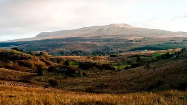
The Slieve Bloom Mountains
The Slieve Bloom Mountains are located in the southern Midlands, in the triangle between the towns of Tullamore, Portlaoise and Roscrea. They are a mild and friendly low mountain range with lots of woodland and numerous loop walks, which are generally easy to moderate-intensity.
The Slieve Bloom Way is a long-distance walk of 75 km. It is a loop trail that starts and ends in Conaslee. You can do parts of it as a day hike.
The Slieve Bloom Mountains are one of Ireland’s largest Nature Reserves and you can expect varied walks in the forests, along the small rivers and over the heather-covered summits. The marked trails are mostly more or less surfaced forest tracks and there are rather few tarred roads to walk on.
Great maps for download can be found here: http://maps.toughsoles.ie/dist-maps/latest/Slieve%20Bloom%20Way.pdf.
The Galtee Mountains
The Galtee Mountains lie a little further south, in the triangle formed by the towns of Tipperary, Cahir and Mitchelshown.
Galtymore Mountain rises 917 metres above sea level, making it one of the highest mountains in Ireland.
Apart from climbing the mountain, you can also take wonderful day hikes along its foothills.
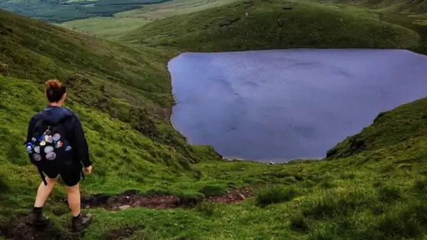
Insider tips are the hikes to Lough Muskry or Lough Curra. Both are small lakes high on the mountain.
If you don’t want to go quite so high, you can also hike at Slievenamuck, a guarded hill or ridge, just north of the Slievebloom Mountains. There are 8 marked loop trails to hike there.
Find maps here: https://blog.hiiker.app/2022/05/06/the-best-walks-in-the-galtee-mountains/.
The Acres Lake Boardwalk Trail
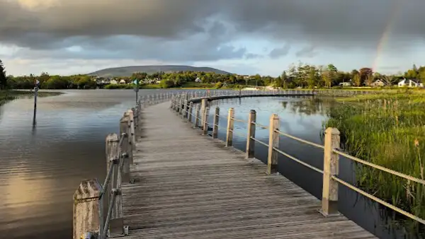
This marked trail is certainly not an expedition, but it is a little sensation.
It starts at the town of Drumshanbo with a 600-metre floating wooden plank walkway in the lake!
It then stretches for 6.5 kilometres to Battlebridge Lock, near Leitrim Village. By the way, we are in County Leitrim, in the northwest of Ireland.
There is also the Drumhauver Bridge Loop Walk, 10 km long, and the Drumleague Lock loop Walk, 5 km long, both of which are connected to the Boardwalk Trail.
See also: https://leitrimtourism.com/walks-and-trails/canal-lakeside-walks/acres-lake-boardwalk/.
Roscommon Miner`s Way and Historical Trail
This marked long-distance trail is an insider’s tip for most people. A pity really, because it offers hiking at its best.
It is 120km long – and of course you can only hike part of it. It is a looped walk, with a peculiar shape, because it actually consists of two loops that are connected to each other and two other sections.
You can enter via Drumshanbo, see also the previous Boardwalk Trail.
On this trail you run through forests, over hills and past lakes.
The Arigna Mines gave the trail its name, or at least part of it. It is a coal mine that you can visit (Arigna Mining Experience). There are also prehistoric and medieval monuments along the way, which probably explains the “historical” in the name.
This is certainly a “hidden gem” because the scenery is beautiful, the trails are varied but not difficult to walk. You can certainly do day hikes here for several days and really relax.
See maps: http://maps.toughsoles.ie/dist-maps/latest/Miner%27s%20Way%20%26%20Historical%20Trail.pdf.
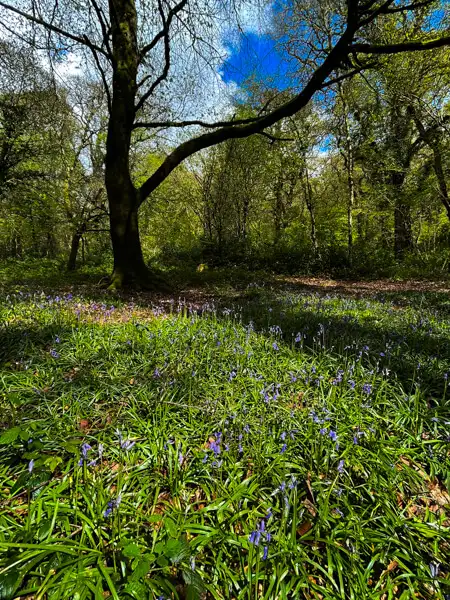
Mullaghmeen Forest
Mullaghmeen Forest is a slightly larger and very beautiful woodland in the northern Midlands, situated not far from Lough Sheelin.
There are several waymarked and partly surfaced footpaths there, all of which are easy to walk. Mullaghmeen is the highest peak in the area and can also be easily reached on marked paths.
A nice area, then, for lovely woodland walks and shorter hikes.
See also: https://www.coillte.ie/site/mullaghmeen-forest/.
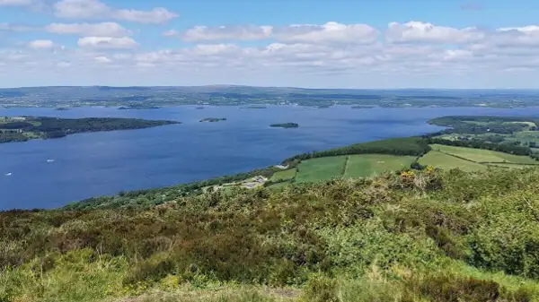
The Lough Derg Way
The Lough Derg Way is a long distance footpath that stretches 70km from Limerick to Dromineer.
Dromineer is situated on the eastern shore of Lough Derg. Lough Derg is one of the largest and most important lakes on the Shannon River, the longest river in Ireland.
You can expect a mixture of lush green pastures, young light forests, hills, watercourses, canals, small rivers, the River Shannon and Lough Derg on your walk.
Several hills can be found on the shores of Lough Derg, offering beautiful views of the lake and surrounding countryside. For a day’s walk, you can take on a beautiful section of the Lough Derg Way.
See maps: http://maps.toughsoles.ie/dist-maps/latest/Lough%20Derg%20Way.pdf.
The Suck Valley Way
The Suck Valley Way is also a signposted long-distance trail. It is a loop trail, with start and finish in Castlerea and a distance of 105km – which you can of course walk in sections. Castlerea is a small town in County Roscommon in the North West Midlands.
The Suck Valley Way passes through “9 friendly villages”, as they call themselves, and indeed you are off the beaten track in rural Ireland – where people are happy to help you and the clocks tick slower – perfect for slowing down!
The trail is easy to walk and takes you over farmland and along rivers. You will have to cross pastures with cows or sheep several times, so always make sure to close the gates behind you and not to scare the animals.
See maps: http://maps.toughsoles.ie/dist-maps/latest/Suck%20Valley%20Way.pdf.
Killykeen Forest Park
Not far from the small town of Cavan, in the northern Midlands, lies a very special landscape, dotted with numerous small and large bodies of water.
There, near Killashandra, lies the Killykeen Forest Park. It offers two marked trails of about 5 and about 10 km in length, which provide a nice mix of forest and lake walking.
See also: https://www.coillte.ie/site/killykeen-forest-park/.
The Cavan Way
The Cavan Way is a waymarked long distance footpath on the border between Ireland and Northern Ireland. It starts in Dowra and runs to Blacklion on Lough MacNena. At only 26km, it is one of the shortest long-distance trails in Ireland.
The first 8-10km of the trail take you from Dowra to Shannon Pot, the source of the River Shannon. It is unbelievable how small the river starts here and how big it becomes after 370 kilometres near Limerick and at the mouth into the sea!
The landscape is characterised by limestone sandstone, there is lush green vegetation which is interrupted again and again by harsh rocks. Meadows and forests alternate and there are several prehistoric monuments along the way, built from the rocks. The hilltops are, as so often in Ireland, rather barren.
This is an overlooked spot – but a very pretty one!
See maps: http://maps.toughsoles.ie/dist-maps/latest/Cavan%20Way.pdf.
The Ballycugarran
Ballycugarran is a hill on the southern side of Lough Derg, on the Shannon. It is wooded and offers 3 marked walking routes, which are rather easy to walk.
The summit offers beautiful views of the lake and surrounding countryside. The trailheads are at Rinnaman Point Qay, a lakeside boat landing on R463.
So if you’re on the south shore of Lough Derg, you might want to check out the trails.
See also: https://www.coillte.ie/site/ballycuggaran/.
Conclusion
Most tourists are drawn to the west coast of Ireland – for good reason. But there are also some – lesser known – beautiful corners to discover inland. For hikers anyway!
Part of the Irish inland is flat and not overly interesting. But if you stick to the small low mountain ranges, like the Slieve Bloom Mountains, or to rivers and lakes, like the River Shannon and Lough Derg, you can always find beautiful walks where others just drive by…
Awaken the explorer in you – and have fun on your walks in the Heartlands of Ireland!
More interesting articles for you
HILLWALKING IN IRELAND: THE MOST BEAUTIFUL ASCENTS FOR EXPERIENCED HILLWALKERS
THE MOST BEAUTIFUL WALKS IN IRELAND’S SOUTHEAST
HILLWALKING IN IRELAND – TIPS ON CLOTHING AND EQUIPMENT
THE MOST BEAUTIFUL HIKES IN IRELAND’S SOUTHWEST
Photo credits cover photo: Sheep on a mountain, photo by Ulrich Knüppel-Gertberg (www.irland-insider.de, www.ireland-insider.com)