In this second part of our series on the Wild Atlantic Way, we travel (virtually) to the far north of Ireland, to Malin Head on the Inishowen Peninsula and then on to the windswept Fanad Head Lighthouse.
Page Contents (click line to jump the text)
Intro
The Inishowen Peninsula is one of the largest peninsulas in Ireland and is located in the far north of Ireland. It belongs to Donegal and is in the immediate vicinity of the Northern Irish town of Londonderry.
Malin Head is the northernmost town on the peninsula and also the northernmost point of the Irish mainland. The Wild Atlantic Way begins there. It stretches 2500 kilometres along the west coast of Ireland to Kinsale in Southern Ireland.
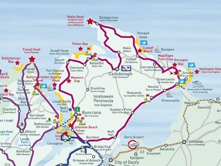
The Inishowen Drive or Inishowen 100
This circular drive around the Inishowen Peninsula is about 100 miles long, which is about 160 kilometres. The signposted route goes once around the peninsula and also includes small side roads and narrow roads.
The Wild Atlantic Way route, also signposted, follows part of the Inishowen 100, starting and finishing in the small town of Bridgend, northwest of Londonderry.
This route can therefore be wonderfully combined with a double overnight stay in Londonderry. Then you can do the Inishowen 100 Tour as a day tour and leave your luggage at the hotel.
If you would like to study the route in detail, you can take a closer look at it on the Donegal tourism page. You can find the site at:
https://www.govisitdonegal.com/things-to-do/itineraries/scenic-routes/scenic-route-6.
Below I show you a few special highlights of the Inishowen Drive:
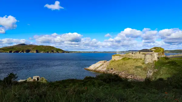
Fort Dunree
This military installation dates from the time of the Napoleonic Wars (early 19th century) and stood guard over Lough Swilly.
Lough Swilly is a fjord, or long sea inlet, formed by glacial melt.
On the other side of the shore is the Fanad Peninsula, where its counterpart is Knockalla Fort. The long fjord runs all the way to Letterkenny and was of strategic importance.
During the First World War, the military installation was once again modernised and revitalised.
The fort is beautifully situated on a rocky headland and offers wonderful views of the fjord. The fort can be visited and today contains a military museum.
Five Finger Beach
This sandy beach, several hundred metres long, is embedded in a dune landscape. The sand dunes, up to 30 metres high, are among the highest in Europe and have existed for about 5000 years. The hilly surroundings are breathtakingly beautiful and on the way to the beach you pass a scenic church.
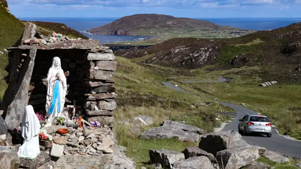
Mamore Gap
The Gap of Mamore is situated in the Urris Hills on the west coast of Inishowen. A small road leads steeply up the hill. At the top of the pass there is a Marian shrine to admire.
But the biggest highlight is the stunning view of the coast. Therefore, it is recommended to drive the Gap from south to north, then you have the coast in front of you.
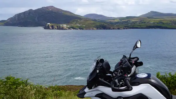
Malin Head
Malin Head is primarily the northernmost point of the island. There is a watchtower from the First World War and a radio station, and that’s almost it. But that doesn’t matter, because the drive there and on around the Inishowen Peninsula is simply beautiful!
The Fanad Peninsula
The Fanad Peninsula is the neighbour of Insihowen. A little less noticed, perhaps, because it is not the northernmost point, but perhaps even more beautiful than this!
The Coast Road
The coastal road via Rathmullan and Portsalon to Fanad Head is certainly one of the most beautiful coastal roads the motorcyclist can find in Ireland. The road really does run right along the water for many kilometres and is simply a joy to ride!
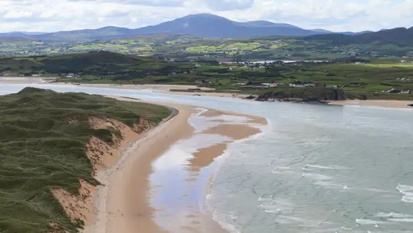
Shortly before Portsalon you come to Ballimastocker Beach and then to Portsalon Beach – both are connected and form a very long, beautiful sandy beach.
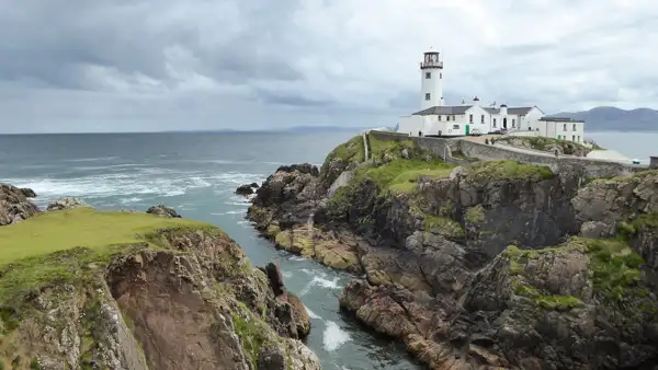
The Fanad Head Lighthouse
The Fanad Head Lighthouse is probably one of the most photographed motifs in Ireland. It is also one of the most beautiful and important lighthouses on the island. Fanad Lighthouse began operating in 1817 and has been open to the public as a tourist attraction since 2016.
There is an exhibition and guided tours, and you can even spend the night in one of the three former lighthouse keeper’s flats. It’s definitely worth a visit, the grounds are really worth seeing and the cliffs in front of it are beautiful to walk on.
The North Coast of Donegal
Even away from the well-known sights, the Donegal region captivates with many beautiful impressions:
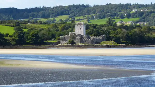
The romantic Doe Castle
Almost at the very end of Sheephaven Bay is the pretty little Doe Castle, right on the water. It is surrounded by water on three sides.
Built in 1420, it was the ancestral home of the McSweeney clan for over 200 years.
The clan originally came from Scotland, so the castle is strongly reminiscent of Scottish towerhouses: a bright square tower rises high in the middle, surrounded by a defiant wall.
The white sandy beaches on the north coast of Donegal
If you follow the coast further west, you will pass several beautiful sandy beaches.
On the north-western shore of Sheephaven Bay is Killahoey Beach, near the village of Dunfanaghy.
A few kilometres further on, near Castlebane, is the picturesque Tramore Beach. A little further on is the very long Magheroarty Beach, easily accessible via the car park at the Tory Ferry.
If you want to take a break, these beaches are wonderful.
Conclusion
The far north of Ireland can be wild and stormy, but also wildly romantic. Rugged cliffs alternate with white beaches.
When the sun shines, the waters of the Atlantic glow in shades of green-blue, and if you stay here on a warm summer’s day, you’ll think you’re on a South Sea beach rather than in the far north of the Irish island.
Admittedly, you have to travel some distance to find your way to remote Donegal, but it’s worth it!
In the next instalment of this series, we find out about the south west of Donegal, close to the main town – Donegal.
More interesting articles for you
IRELAND’S WILD ATLANTIC WAY – PART 3 – GLENCOLUMBCILLE AND THE CLIFFS OF SLIEVE LEAGUE
IRELANDS WILD ATLANTIC WAY – PART 4 – CEIDE FIELDS AND ACHILL ISLAND
IRELAND’S WILD ATLANTIC WAY – PART 1 – AN INTRODUCTION TO THE WORLD’S LONGEST COASTAL ROAD
A HISTORICAL ROUND TRIP IN IRELAND’S ANCIENT EAST
Photo credits cover photo: Fanad Head Lighthouse, photo by Ulrich Knüppel-Gertberg (www.irland-insider.de, www.ireland-insider.com)
Picture credits map: www.govisitdonegal.com